|
Introduction | Standard
Map | Extended Map | Scenarios | Alternative
Maps | Subchaser's Map | FAQ | Map Data Files | Map
Examples
|
| Introduction |
Andrew Brown's War in the Pacific Map is a complete new
map for War in the Pacific. The map is now at Version 6.2.
The main
differences between the modified map and the
official map are:
- Many parts of the map have been moved and/or redrawn
to make the distances between various parts of the map more accurate.
Some detailed comparisons are provided on this page.
- The transport infrastructure in Australia has been
modified to make it more accurate.
- The transport infrastructure in North America has
been modified to make it more accurate.
- Muck of the terrain and transport infrastructure in
China has been modified to make it more accurate.
- Some extra bases, such as the Maldives and the
Society Islands have been added.
- Some additional terrain types have been added.
The map also includes the same LCU movement fix
contained in my old LCU movement mod.
This page contains some examples of the new map. Note
that these examples are all JPEG format, so they are reduced in quality
from the original map. Some of the alternative maps are available as
separate downloads.
For a detailed description of the new map and the
changes that I have made, please read the Andrew's map documentation.
|
Standard
Map
|
Some of these files are made available on Spooky's UV and WitP Fansite, rogueusmc's WitP Fansite
and
Richards War in the Pacific Page. My thanks to Spooky, rogueusmc
and Richard.
|
| Extended
Map |
Extended Map
A special "extended" map has been created for the
Combined Historical Scenario (CHS) that is being developed by a number
of players. This extended map adds two "off map areas" to the map -
Panama/Galapagos Islands and the Middle East/Africa.
The extended map is designed to be downloaded and
installed after version 6.2 of my map has already been installed.
| Andrew's War in the
Pacific Extended map version 6.2 (47.3 MB) |
 |
Alterative
location 1 - Spooky's site |
|
|
Alterative
location 2 - rogueusmc's site |
| |
Alterative
location 3 - Richards War in the Pacific Page |
| Planning map (9.1 MB). |
 |
This is a single JPEG file of the entire map. To
save the file to your PC, right-click on the image and select "save
picture" or "save image". |
Version 6.3 map data file
(30
KB)
|
|
This file can be
used to update the extended map to version 6.3. Please see the included
Readme file for details.
|
Some of these files are made available on Spooky's UV and WitP Fansite, rogueusmc's WitP Fansite
and
Richards War in the Pacific Page. My thanks to Spooky, rogueusmc
and Richard.
|
| Scenarios |
For a list of scenarios that can be used with my map,
please see the Scenarios page.
|
| Alternative Maps |
Several styles of alternative maps are available, as
specified in the following table. If using my standard map, then
download the standard version only. If using ONLY the special extended
map, then download the special map only. If using both maps, then
download both if desired.
All alternative map files are approximately 22-23 MB in
size.
* WiF = "World in Flames" style hexdots for sea areas
Zones are weather zones, Malaria zones
and control zones.
|
| Subchaser's
Map |
Subchaser has made a version of my Version 4 extended
map. The main difference with his version is the use of his much better
looking and easier to read fonts. Also, in the hex version of the map,
the hexes are only present in the ocean/sea hexes, not the land hexes.
Apart from these changes the map graphics are the same.
There is no standard map variant of Subchaser's map -
only the extended map variant.
Note: This is a
modification of my version 4 map, not the latest version (version 6.2).
Here is a sample of his version:

The map, including both the hex and non hex versions is
available here:
Subchaser's
map version (39.5 MB)
To install the map, version 4 of my standard and
extended maps must first be installed. Then, download and unzip the
file and place all of the files contained in the zip file into the
"ART\Maps_Modified_v4X" folder located where War in the Pacific is
installed.
|
FAQ
|
A Frequently Asked Questions (FAQ) page
is available, providing some information about the map and help for
some common problems.
|
Map
data files
|
Map data files
("pwhex.dat")are available here as separate downloads in case your one
is "misplaced".
Note: These files are ONLY
necessary if you need to replace a lost map data file. You do not need
to download these files to install my map - the map packages provided
on this page already contain their corresponding map data files.
Once unzipped in the locations specified in the table, run the
"ModSelect" utility to install the map data file. "[Game folder] in the
table below is the folder where WitP is installed, usually "C:\Matrix
Games\War in the Pacific".
Standard map data file,
version 6.3
|
|
When
unzipped, the file should be placed in the "ART\Maps_modified_v6"
folder.
|
| Extended map data file,
version 6.3 |
|
When unzipped, the
file should be placed in the "ART\Maps_modified_v6X" folder. |
Official
map data file, patch
level 1.6
|
|
When unzipped, the file should be placed in the
"ART\Maps_official" folder. |
|
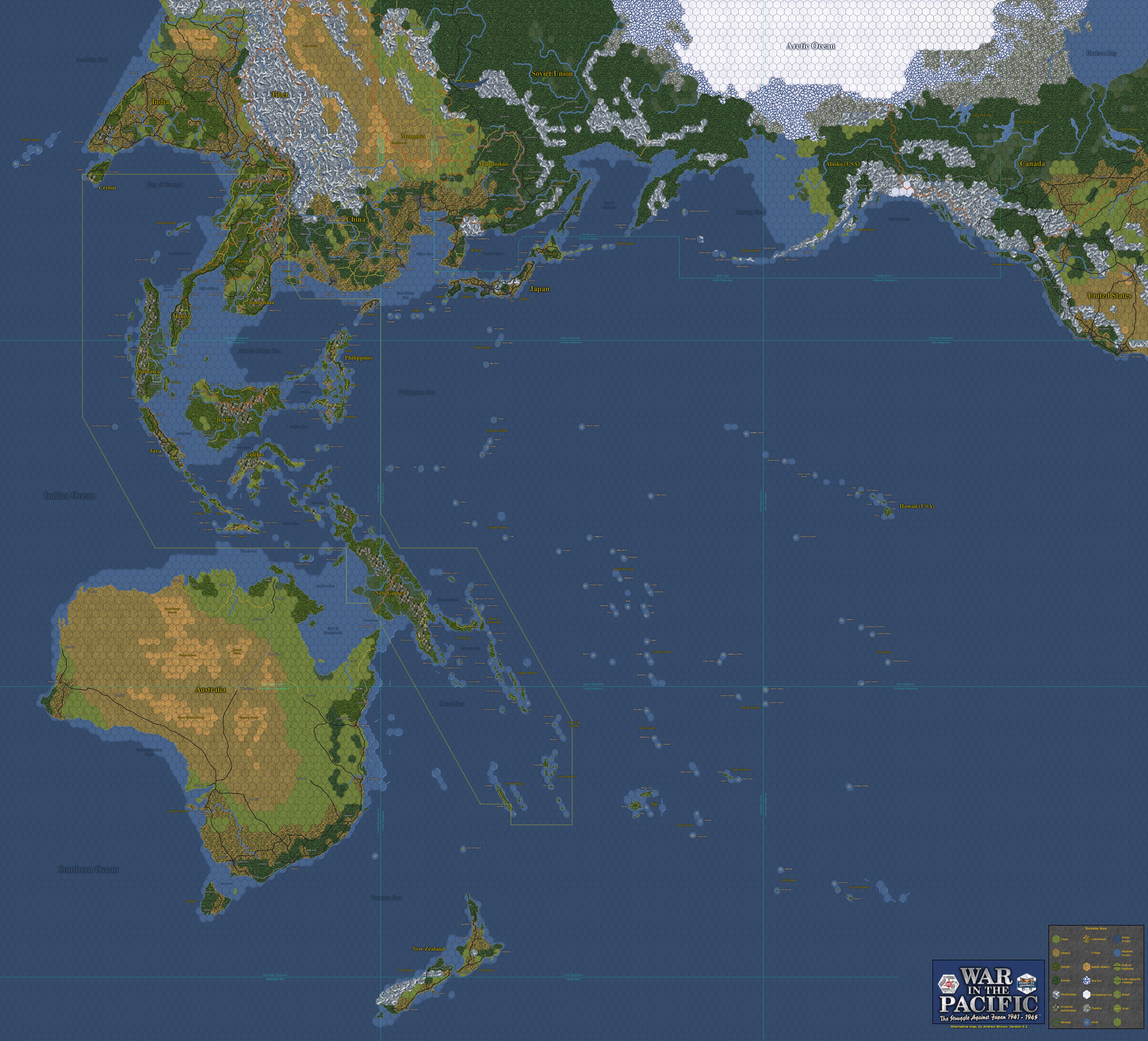
This is a small scale copy of the full (version 6.2) map:

Map examples
The following examples show some of the artwork for the map in
various versions, with or without a hex grid. Some common features of
the map examples are:
- The 3D look of the official map is replaced by a more
traditional 2D look, with terrain types drawn with a consistent look to
make it easier to identify the terrain type of a hex (also I am not
much of an artist and this was an easier way to draw the map).
- The solid white line is a control area boundary.
- The dotted aqua line is a weather area boundary.
Note:These map examples are taken from the version 2
map. Version 3 examples will be provided soon.
Map with light hex grid:
This example shows part of the map with a modified hex grid.
The land sections of the grid are a bit lighter, and the water sections
are ligher still and a blue colour, instead of grey or black. Weather
and Malaria zones are indicated. This map is included with the mod as
the "map with hexes".

Map with light hex grid
Map without hex grid, hexside indictors or
zones:
This example shows part of the map without a hex grid, hexside
indicators, control zones or weather zones. This map style is most
similar in style to the official "No hexes" map. This map is included
with the mod as the "map without hexes".

Map without hex grid, hexside indictors or zones
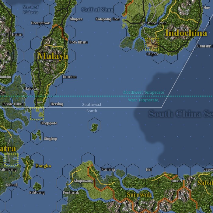
Alternative
Hex Map 1 - Map with light hex grid, hexside indicators, weather zones
and control zones:
This example shows part of the map with a the same light hex
grid as above, but with hexside indicators and control zones visible as
well as weather zones. The hexside indicators are added for hexsides
where it is not clear whether the hexside type is Land, Ocean or
Blocked.

Map with light hex grid, hexside indicators, weather zones and control
zones
Download this map variant:
Standard map
Extended map
Planning
map (standard)
Planning
map (extended)
Alternative
Hex Map 2 - Map with "World in Flames" style hex grid, weather zones
and control zones:
This example shows part of the map with a hex grid similar to
that used for the board game World In Flames. This hex grid uses "dots"
instead of hexes to represent sea/ocean areas. This map also includes
weather and control zones.
Map with "World in Flames" style hex grid, weather zones and control
zones
Download this map variant:
Standard map
Extended map
Planning
map (standard)
Planning
map (extended)
Alternative
Hex Map 3 - Map with "World in Flames" style hex grid, hexside
indicators and weather zones:
This example shows part of the map with a the same "World in
Flames" style hex grid as above, but without the Control Zone
boundaries, and with hexside indicators added for hexes where it is not
clear whether the hexside type is Land, Ocean or Blocked.

Map with "World in Flames" style hex grid, hexside indicators and
weather zones
Download this map variant:
Standard map
Extended map
Planning
map (standard)
Planning
map (extended)
Alternative
Hex Map 4 - Map with light hex grid - no zones or indicators:
This example shows part of the map with the light hex grid,
but without the control and weather zones.

Map with light hex grid - no zones or indicators
Download this map variant:
Standard map
Extended map
Planning
map (standard)
Planning
map (extended)
Alternative
Hex Map 5 - Map with light hex grid and hexside indicators - no zones:
This example shows part of the map with the light hex grid,
including hexside indicators, but without the control and weather zones.

Map with light hex grid and hexside indicators - no zones
Download this map variant:
Standard map
Extended map
Planning
map (standard)
Planning
map (extended)
Alternative
Hex Map 6 - Map with plain hex grid:
This example shows part of the map with a plain hex grid,
similar to the one used on the official map. It does not contain
hexside indicators or control zones. This hex grid is most similar in
style to the official map.

Map with plain hex grid
Download this map variant:
Standard map
Extended map
Planning
map (standard)
Planning
map (extended)
Alternative
Hex Map 7 - Map with light hex grid, weather zones and control zones:
This example shows part of the map with the light hex grid,
including control zones and weather zones.

Map with light hex grid, weather zones and control zones
Download this map variant:
Standard map
Extended map
Planning
map (standard)
Planning
map (extended)
Alternative
Hex Map 8 - Map with "World in Flames" style hex grid - no zones:
This example shows part of the map with a hex grid similar to
that used for the board game World In Flames. This hex grid uses "dots"
instead of hexes to represent sea/ocean areas. This map variant nas no
weather or control zones.

Map with "World in Flames" style hex grid and no zones
Download this map variant:
Standard map
Extended map
Planning
map (standard)
Planning
map (extended)
Alternative
Hex Map 9 - Map with "World in Flames" style hex grid, weather zones:
This example shows part of the map with a hex grid similar to
that used for the board game World In Flames. This hex grid uses "dots"
instead of hexes to represent sea/ocean areas. This map variant has
weather zones but not control zones.

Map with "World in Flames" style hex grid, weather zones
Download this map variant:
Standard map
Extended map
Planning
map (standard)
Planning
map (extended)
Alternative
Hex Map 10 - Map with light hex grid, weather zones, and NO TEXT:
This example shows part of the map that is the same as the
standard hex map, but without any base, land or ocean text.

Map with light hex grid, weather zones, and no text.
Download this map variant:
Standard map
Extended map
Planning
map (standard)
Planning
map (extended)
Alternative
No-hex Map 1 - Map with no hex grid, with weather zones and Control
Zones:
This example shows part of the map with no hex grid, but
including weather zones and control zones.

Map with no hex grid, with weather zones and control zones
Download this map variant:
Standard map
Extended map
Planning
map (standard)
Planning
map (extended)
Alternative
No-hex Map 2 - Map with no hex grid, no weather zones, no Control
Zones and no text:
This example shows part of the map with no hex grid, weather
zones, control zones or text. This is the cleanest map available.

Map with no hex grid, no weather zones, no control zones and no text
Download this map variant:
Standard map
Extended map
Planning
map (standard)
Planning
map (extended) |
 Planning
map (extended)
Planning
map (extended) Planning
map (extended)
Planning
map (extended)
 Planning
map (extended)
Planning
map (extended)
 Planning
map (extended)
Planning
map (extended)
 Planning
map (extended)
Planning
map (extended)
 Planning
map (extended)
Planning
map (extended)
 Planning
map (extended)
Planning
map (extended)
 Planning
map (extended)
Planning
map (extended)
 Planning
map (extended)
Planning
map (extended)
 Planning
map (standard)
Planning
map (standard) Planning
map (extended)
Planning
map (extended)
 Planning
map (extended)
Planning
map (extended)
 Planning
map (standard)
Planning
map (standard) Planning
map (extended)
Planning
map (extended) 