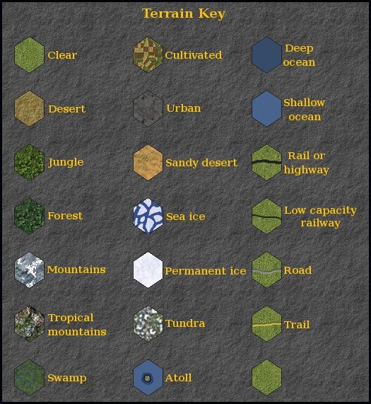
The terrain types present on the map are shown in the
following diagram:
This table provides a brief explanation of the terrain
types included on my map. It is not actually possible to
add new terrain types, so the "new" terrain types I have
added are merely different visual representations of
existing terrain types:
| Terrain type |
Description |
| Clear |
The same as the official map. |
| Desert |
The same as the official map (that
is - the same as clear terrain). |
| Jungle |
The same as Forest/Jungle on the
official map. Temperate forest and tropical jungle
are drawn in different colours for aesthetic
reasons. |
| Forest |
The same as Forest/Jungle on the
official map. Temperate forest and tropical jungle
are drawn in different colours for aesthetic
reasons. |
| Mountains |
The same as mountains on the
official map. Two types of mountains are drawn for
aesthetic reasons. Non-tropical mountains are drawn
with snow. |
| Tropical mountains |
The same as mountains on the
official map. Two types of mountains are drawn for
aesthetic reasons. Tropical mountains are drawn
without snow. |
| Swamp |
The same as swamp on the official
map. |
| Cultivated |
The same as cultivated terrain on
the official map, except that in Australia, New
Zealand and North America cultivated hexes contain
roads instead of trails. |
| Urban |
The same as urban terrain on the
official map. |
| Sandy desert |
Sandy desert is an alternative
visual representation of swamp terrain, with the same
effect in the game. |
| Sea ice |
Sea ice, like permanent ice on the
official map, is prohibited terrain. It is included
for aesthetic purposes. |
| Permanent ice |
The same as permanent ice terrain on
the official map. |
| Tundra |
Tundra is an alternative visual
representation of swamp terrain, with the same effect
in the game. |
| Atoll |
The same as atolls on the official
map. |
| Deep ocean |
The same as deep ocean on the
official map. |
| Shallow ocean |
The same as shallow ocean on the
official map. |
| Low capacity railway |
Low capacity railway is the same as
Road in the map data, but is drawn differently. It is
intended to represent railways that were not capable of
transporting large numbers of troops. |